Graphic Explanation of Globally Unique Identifiers (GUIDs) in the CR Spatial Data Transfer Standards
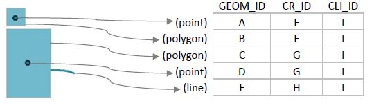
Each representation of any feature–whether a point, line or polygon–has its own “Locational GUID”, or GEOM_ID. After that, each physically distinct cultural resource has its own “Cultural Resource GUID”, or CR_ID. Finally, all various representations of the same CLI feature will have the same “Analysis Evaluation Feature Identification Number”, or CLI_ID, which is an existing 6-digit identifier stored in the CLI for each feature. The following is a graphical illustration of this system, and how it would work given several different feature examples.
note: A GUID looks something like: C84087D5-E035-4275-8E3C-444617049CC0
Olson Well

Hans Halseth House
Sugar Maple Trees
Fences

Barn, Milkhouse and Retaining Wall
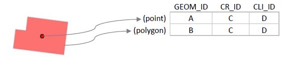
note: composite features like this are found in the CLI from time to time